Friday, October 19, 2007
Ballpark Seats
The folks at http://www.ballparkseats.com have the only known example of a figural seat from League Park. They have quite a website loaded with seats from lots of ballparks and arenas. Check 'em out. The lone figural side shown to the left is from the auction house Lelands. The sides were sold in several different auctions. What a beautiful art nouveau design!
Sunday, July 8, 2007
League Park
Microsoft's Live Search has a feature called "Bird's Eye View". If you're lucky, you can find what you're looking for in sort of a 45 degree aerial view. It's at Local.live.com Here are some of the views available for League Park. Go to Live Search at Local.live.com and plug in your destination. Click on the little buildings that are popping up in sort of a 3D angle (under the 2d section). That's the Bird's Eye View feature. Once you have the Bird's Eye View, there is a compass tool that allows you to switch your viewing angle. Looking at these images gives you a true understanding of the site and how the existing wall fits into the scheme of things. Until a couple years ago, the concrete base to the lower deck stands behind that wall also existed, but it was crumbling and a safety hazard. Thanks to Lenny Difranza of the Hall of Fame and his webparks blog for this realization. He has been building a site that includes links to various web resources. At his site he has a picture of the Braves Field Windows Live image and from there I stumbled upon the compass points. Good stuff! Thank you Lenny for also giving me assistance on my Ebbets Field image on the New York Historic Ballparks poster.
The Posters Have Arrived!
The posters are here from the printer and are now available. Check out the site historicballparks.com for more information. I think they're the best yet (unless you hate Boston and New York, in which case they're suitable only to be used as shelf liner, preferably in the garage, underneath your more hazardous chemicals, such as paint solvents or pesticides).
Thanks to everyone who gave me suggestions and input!
Wednesday, June 20, 2007
Addie Joss Day
Tuesday, June 19, 2007
League Park
These are blueprints for the (then) planned demolition of League Park. I obtained a copy of them from the Parks department of Cleveland . You can see where the wall was capped off. That current wall is still standing, along with the ticket office. By the way, these are the only blueprints that feature the ticket office, as when Osborne engineered the brick and steel version of the park in 1910, the office was already standing and wasn't included in those drawings.
Wednesday, June 13, 2007
League Park
Phew, it's been a while since the last post. My apologies. I'll try to do better. A new initiative was announced last week to save what exists at League Park at Cleveland and expand upon what's there. Here's the full story at the cleveland.com's blog . Some people have linked to the cleveland.com article that doesn't have any images. The blog entry that's linked here includes this image. Will it happen? Who knows. There have been proposals before for townhouses associated with the site and a museum. One thing's for sure... League Park deserves better than what's been happening to it for the last ten years (although it did get a paint job that stripped it of the previous Pepto Bismol pink).
Unfortunately, the city of Cleveland doesn't have a lot of money to throw around to such projects. Forty three per cent of the seniors in its school system couldn't pass the state graduation exam and have to return to High School next year! However, when you hear about how poor Cleveland is, remember that its boundaries are fixed and when the population shifts and moves outward, those people are gone from the tax rolls and aren't counted in the city's population. Whereas a city such as Columbus, Ohio keeps on annexing the surrounding land year after year, giving a skewed picture as to how affluent the citizens are in each of the cities.
Wednesday, May 16, 2007
Google SketchUp
This is a rough shadow study of the West Side Grounds in Chicago. It's based on a 1917 Sanborn Map. The shadows start at about 9 or 10 in the morning and proceed from there. The date is set for September 26 so as to get some longer shadows.
Thursday, May 3, 2007
West Side Grounds
Mike Reischl has told me about his website thewayoutinleftfieldsociety.org
It's a site devoted to the previous home of the Chicago Cubs, the West Side Grounds. Some of these photos are from his site. Be sure to check out the statues on top of the ticket office!
Thursday, April 19, 2007
Huntington Avenue Grounds (again)
Thursday, April 12, 2007
Wednesday, April 11, 2007
Braves Field
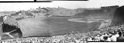
Here's a stitching together of three photos of Braves Field in 1930 that are up on the Sports Temples of Boston site.
Monday, April 9, 2007
Thursday, April 5, 2007
South End Grounds
While conducting research into the South End Grounds, it was discovered that the Hall of Fame in Cooperstown has a digital recreation of the Grand Pavillion, the version most of us think of when we do think of SEG. I contacted Tom Shieber and he told me all about the project. It's coming about in three stages. The first stage has been completed with the digital recreation of the Grand Pavillion. The second stage is in progress with a recreation of Ebbets Field, and the third stage will be old Comiskey Park. I'm not really sure how you view the park. Gives one a good reason to go to Cooperstown (besides the obvious reasons) don't you think?
Tuesday, April 3, 2007
Huntington Avenue Grounds
Here's more shots from the Sports Temples of Boston site.
"Fans leaving the Huntington Avenue Grounds after doubleheader between the Boston Americans and Cleveland on Bunker Hill Day." Note the arch of the entrance way off in the distance. That's the same arch that is shown here.
Satchel
This doesn't have anything to do with ballparks, but while searching through the Sports Temples of Boston site, I discovered this wonderful photo. The caption is "Satchel Paige, pitching for the Kansas City Monarchs of the Negro League, warms up before a game at Braves Field." Check out the hole in Satchel Paige's sock. Beautiful.
Saturday, March 31, 2007
Fenway Park
Here is how the new illustration of Fenway Park is looking. Bob DeCoteau is a Fenway Park tour guide and student of the early history of Fenway. He's been helping me with this. I still have a couple questions. The illustration is supposed to represent the park in it's first few years. Does anyone know if Duffy's Cliff ran all the way along the wall? Was the flag pole there yet? Also the Bromley map of that era indicates a small building that I've circled. Does anyone know what that looked like? Thanks for any help. These three images are all from the Sports Temples of Boston site.
Friday, March 30, 2007
Huntington Avenue and South End Grounds
Here's two photos of Huntington Avenue Grounds (pieced together in the computer) with South End Grounds (a single decked version, not the famous double decked version) visible in the background. The year is 1911 and the photos were taken from an "aeroplane". Tom Shieber of the Baseball Hall of Fame tipped me off to this. The photos are from the aforementioned Sports Temples of Boston website.
Sanborn Maps
It's been requested that I include the Sanborn map that includes Huntington Avenue Grounds on the blog. Here it is. It's not a Sanborn map though, it's a Bromley map. From 1908. For those who are confused, much old building research is conducting by browsing through old Fire Insurance maps. These maps had most of the information that insurance companies needed to assess the risk of the building being destroyed by fire (access to water mains and running water, number of floors of building, window location, construction materials, etc.). Sanborn was the leader in this field, so they are generically called Sanborn maps. Bromley was a lesser known insurance map maker of the time (maybe someone else has more details on this issue). There are some online resources (Proquest comes to mind) that are "pay to play" to access these maps. That makes Marc Okkonen's research all the more remarkable, for I'm pretty sure he traveled to all of the different cities to study their newspaper and map collections.
Thursday, March 29, 2007
Marc Okkonen
The man who I think deserves the most credit for spreading the knowledge of early 20th century ballparks is Marc Okkonen. He wrote a series of Baseball Memories books in the early 1990's. His "Baseball Memories 1900-1909" had unique aerial view drawings/maps of whatever ballparks the major league teams played in during that time period. He drew these using the old fashioned method of plotting out perspective vanishing points and then laying out old fire insurance maps into that perspective grid. He then drew the buildings up from that base. For the purpose of the book, he was sure to include the angle of the midday and setting sun, knowing that was information any baseball fan would need to imagine themselves at those games. Take a look at this remarkable view of the two Boston ballparks of the day, South End Grounds and Huntington Avenue Grounds.
His books also help put things into the perspective of their time. Included are all of the newspapers of the era and the sportswriters who contributed to them. Also in each book are a couple pages describing the popular culture of the time and a mention of the peculiarities and customs of the game of that era. Oh, and they also have player, manager and owner photos galore. You know that Marc spent a LOT of time poring over all the newspapers of the era.
The only complaint one would have is a biggie, in that most of the reproductions are from photocopies, not photos of the original newspaper clippings. I would assume most of that is from the weak microfilm sources. I curse the day microfilm was adopted. Why couldn't libraries have waited 40 years until true digital technology came about before tossing their bound copies of newspapers away?
I urge anyone with an interest in these old wooden parks to pick up this book through a used bookseller. I've seen a bunch on Amazon through various used book dealers.
That is One Big Wall
Take a look at this image from the Sports Temples of Boston site of the outside of the Huntington Avenue Grounds outfield wall. How did that guy get up there? A grappling hook?
Those are some mighty big advertisements.
Tuesday, March 27, 2007
Google Sketchup
Here's a different view of the simple 3d model of the Huntington Avenue Grounds that was created for this new ballpark poster project. It was created in Google Sketchup. It's nice because you can set the time of day and year and the shadows adjust accordingly. The model was created on top of an old Sanborn fire insurance map.
The Huntington Avenue Grounds
Subscribe to:
Posts (Atom)